


 Långå Skans. Fortification that was added after the peace of Brömsebro 1645 when Härjedalen, Jämtland and Gotland became Swedish landscapes. The current star-shaped bulwark replaced an earlier one, was built and completed years 1700. Långå was given a significant role in the defense of Sweden at the end of the 17th century, then Långå, according to the new fortification scheme adopted during Queen Kristina's time, was designated as a strategically important site for a fortification for the protection of the province of Härjedalen, along with other scans located in the border areas towards Norway. Långå Skans is worth a visit both for historical and cultural reasons and as a scenic experience at Långåljusnan's beach.
Fighting has never been fought at the odds, but a fortuitous soldier lost his life due to illness and is buried in the skull's burial ground in the field east of the skull. summer 2020 forty soldiers who are buried there with a memorial stone were honored; ‘The grave of the unknown soldier’. It is a unique memorial of its kind in Sweden.
During many summers from the mid-1940s, Långå Skans was a popular party place, with the mentioned and alluring midsummer celebration.
More information is available on the website www.langaskans.se
The ancient defense in Skansberget is a long one, man-made stone mason, which was built as a defense and fortification at some time during the many years of violence that dominated both the Norwegian and Swedish times. Unclear when it came to, but probably sometime on 1400- or the 16th century. Marked path leads to the guard from the road to Skansberget. The terrain consists of boulders with cavities so you should be attentive and careful.
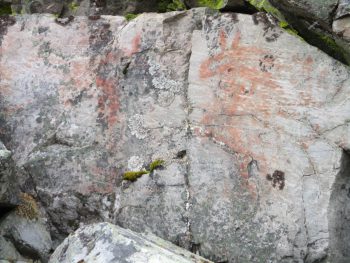
The rock paintings in Mount Hovden, west of Långå. Skip village road straight, pass billboard “This ends the public road” and continue for about 1 kilometers of Mittåbron. The sign on the right. The rock paintings are more than four thousand years old and typical of the fish of the time- and hunter people.
Photo: Margareta Selin-Ring
Soldier tomb after the old road to Långå, Karl XI:s way. Two “Swedish warriors” are buried here, presumably officers with the names Birch and Aspen. On their fenced grave planted a birch or an aspen sometime in the 1940s. Oddly enough, they have not grown or changed since they were planted.
THE FISHING LOCATION at Långå Skans is a meeting place around the campfire for anglers and others who want to have a nice time for relaxation and fellowship. Access for all visitors, those interested in fishing and school classes with free fishing along the stretch of stream. At the site, Långåfisket and Sportfiskarna can arrange training and theme days to increase knowledge and skills in sport fishing. Individual anglers and families can always use the installations and the grill for their own needs. The place is prepared for training and practice in throwing technique.
Unnsån (21 on the map) lets their winding race take the road across historically interesting meadows where farmers in the village used every opportunity to take hay as winter fodder for cattle and horses in barns and stables. Langåfisket's cultural workers have identified interesting, paved roads used and renewed erected signs with names of different places and meadows. Stop and imagine the tiring but lively work. The scarce harvest was gathered and laid in 'flakes’ , says Bolla Johansson, and was transported home on the winter. One 'wreck’ filled a gutter and could feed a cow about a week which meant a few tens of liters of milk and a little cream. Cheese and brass butter were made from the milk. The cream was coreed to butter. On the west side of Unnsån, about halfway from the car road up to lower Unnsajön on the west side there is a nice rest house that welcomes you. Follow Unnsån's west bank from the car park by the road bridge.
Mittåfallet following the old road to Grundsjön from Långå. A mighty big cases and a smaller threshold drop just upstream was a magnificent sight before Mittån was converted into electricity and the water flow was led into long power plants. Still, one can imagine how it looked. In fallhöljan below the fall are trout of the old stock left. It is possible to climb down there at your own risk but be very careful. The old stone coffin along fallhöljans one side should not be entered.
Downstream is a long canyon that require advanced casting technology. Use Spey cast.
Midfall is a popular swimming spot and is used for its dramatic nature- and beauty experiences. great care recommended below own responsibility!
Rändåfallen One kilometer upstream from the parking lot at the western entrance to Långå. Very easy to reach through shorter hikes and is definitely worth a visit. RANDAN has been led down the tunnel to lengthy power plants for electricity production with only modest flow that result. Rändåfallen, it is more in line, are still worth visiting for the large number of cases that the water throws itself over. There are timbered rest cabin. Include in. Note ban on graffiti and littering.
Sågströmmen, Långåfallet and Saxvall. Wave 84 crosses the Långåljusnan west of the village and just upstream of the road bridge the Rändån mouth. Sågströmmen (No. 44 on the map) already gossiping about the name of what it was used for and remnants of the old saw remained in the 1950s. It was of considerable size compared to the small water-powered saws found in several places in the village, during the early nineteenth century supplemented with a steam engine powered saw. During the 1920s, the saw current gained a new meaning with emphasis on 'current’ then the power of Långåfallets falling water was converted into electricity and supplied the village with electricity, mainly for lighting. In winter time, it was supported by a noisy diesel until 10 am 22.00. Electricity consumption was measured in 'number of bright spots’ and caution meant that most satisfied themselves with a bright spot (lamp) in the rooms used. Long before, kerosene lamps had been introduced; An advantage of the electric lighting was that the lamps did not light up. Before the kerosene lamps, burning tar sticks were used as lighting in barns and sheds. It's easy to understand what excitement they gave!
At Saxvall a modern hedge was built (fortification) at the beginning of the Second World War and formed an effective barrier in the valley with concrete barricades and explosives in the bridge. When the current bridge was built, the dam was renewed but is now taken out of service.
Långåbadet for play, bad, grilling, tennis, fishing and relaxation. Långåbadet located in Stortjärn within lengthy village.
Estimated put&take-fishing with a BL regnbåge. Popular angling for pike in winter. Boat for rent.
Long Ågården and Benefits&Pleasure. The village has two community centers, Long Ågården and Benefits&Fun-premises (The community House). Långågården is a popular meeting place for cultural activities, family gatherings, meetings and services. Långågården is a gathering place for crafts with traditions from the village's cultural history. There is also a nice bakery cabin for thin bread baking and pizza.
benefits&The entertainment room is used for what it is called. There are gatherings with larger audiences at both public and private events.
Installations in Gruckån for cushioning the river and logging. Interesting relics of the forest industrial era. Remains from the old timber gutter for floating timber. The construction of the gutter is said to have been the largest construction project of the time with enormous work efforts by very many people involved.. Many compare the project with recent dam constructions for hydropower. A unique phenomenon in the forest industrial transport system. The gutter was able to hold water the entire distance down to Lake Orten and thus connect to Långåljusnan.
Hammarberg Levees. Old road to Grundsjön, west from long village. Turn right west of the village and proceed to the sign Hammer Hill on the right side. Well-preserved mountain pastures.
Nilsvallen. Fäbodvall with centuries-old origins. Belongs to the farm OPPiNILS. Parts of the farm's livestock stay on the summer pasture in the summer when a summer café also opens there. Interesting and educational guide for those who are interested in nature and cultural history. Sales of farm products. Website: www.oppinils.com
Långåvålen. Take the old road to Grundsjön, bay of the Little Sältjärn and follow the signs to long Turbines. Formerly a quiet place with views that extend into Norway, Jamtland, northern Dalarna and down to Hälsingland. Used during the summer in the 1900s for forest fire monitoring. The old view tower remains from that time.
Lillfjället, on the south side of Grundsjön. Easy walking with exciting nature types in varied moorland with beautiful oases where finds can be made from the mountain flora. rich birdlife. Ren, Moose, fluff and bear. Nice rest cottage on the eastern slope, halfway below the top, even with the possibility of an overnight stay. Popular excursion destination during winter time but also for hikers during the summer.
Långåknätten, the mountain with the 'eggshell top’ is the mountain range that separates the Långådal corridor to the south. A telemast stands at the top and there leads a transport road that is open for traffic via Skaltjärn, 68 on the map. The last bit can easily be climbed on foot, especially if the road surface is not completely safe. Adorable views of Långå village and its surroundings.
The long-haired beach path which goes east from the parking lot at Skräddarsundet, No. 58. Beautiful walk in magical forest after a few hundred meters. Plenty of places suitable for spin fishing and fishing (kastflöte).
Eden destruction became the name of the approx 70 Miles long footpath that pilgrims in the Middle Ages wandered from Munktorp at Lake Mälaren just east of Köping to Nidaros, current Trondheim approx 25 miles from Långå into Norway. The pilgrimages to Olav the Holy Sepulcher lasted until the Reformation 1528, when these were banned. Romboleden is marked within the Långå fish conservation area (se kartan)
The green spring No. 80 on the fishing map. A strange little pond with a small 'archipelago'’ and which with its large bottom springs have an icy cold water and green shimmering water due to the bottom sediments. The green spring contains trout, probably with a locally formed species of the trout that characterizes Ljusnanöringen in western Härjedalen.